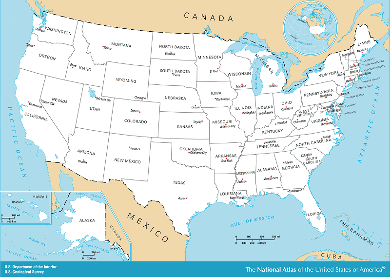
QUESTIONS - Examine the maps and answer the questions. Map of the 50 United States
What is this country called?
Who governed the land that later became the United States of America before the signing of the Declaration of Independence in 1776?
How did Americans obtain their freedom from England?
Which great man led the American Army during the American Revolution?
How many states are there?
Which is the largest state?
Which is the smallest state?
Which state is farthest south?
Which state is farthest northeast?
Which state is farthest west?
Which states border the Pacific Ocean?
Which northern state is almost surrounded by lakes?
Which is the largest of the great lakes?
Which large river flows into the Gulf of Mexico?
Which large rivers flow into the Mississippi River?
Into what does the Ohio River flow?
Which river divides Texas and Mexico?
Which ocean is east of the United States?
Which ocean is west of the United States?
Which country is north of the United States?
Which country is south of the United States?
If you live in the United States, in which state do you live? Where is it on the map?
If you live in the United States, which states surround your state?
What are the names of the Great Lakes?
How many Great Lakes are there?
Which lake is in Utah?
Between which gulf and ocean is Florida?
Which three states touch Lake Superior?
Which four states touch Lake Michigan?
Which four states touch Lake Erie?
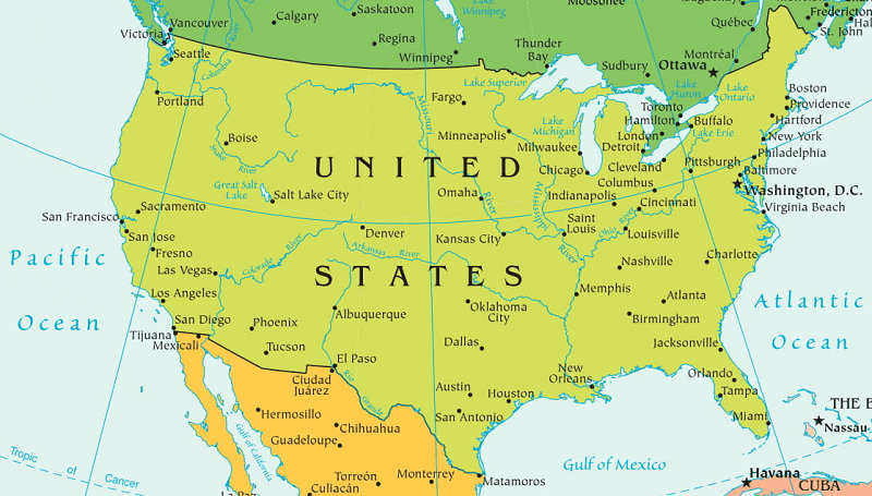
ANSWERS Select United States Lakes and Rivers
This country shown is called the United States.
The king of England governed the land that later became the United States of America before the signing of the Declaration of Independence in 1776.
Americans obtained their freedom from England by a war, the American Revolution, which lasted nearly eight years.
George Washington led the American Army during the American Revolution and later became our first President.
There are 50 states.
Alaska is the largest state.
Rhode Island is the smallest state.
Hawaii is the farthest south of all 50 states, while Florida is the farthest south of the continental states.
Maine is the farthest northeast state.
Alaska is the state farthest west.
Washington, Oregon, and California border the Pacific Ocean.
Michigan is almost surrounded by lakes.
Lake Superior is the largest of the Great Lakes.
The Mississippi River flows into the Gulf of Mexico.
Mississippi tributaries include the Missouri River, the Ohio River, the Arkansas River, and many others.
The Ohio River flows into Mississippi River.
The Rio Grande River divides Texas and Mexico.
The Atlantic Ocean is east of the United States.
The Pacific Ocean is west of the United States.
Canada is the country north of the United States.
Mexico is the country south of the United States.
Answers vary, depending on where you live.
Answers vary, depending on where you live.
The names of the Great Lakes are Superior, Michigan, Huron, Erie, and Ontario.
There are five Great Lakes.
The Great Salt Lake is in Utah.
Florida is between the Gulf of Mexico and the Atlantic Ocean.
Lake Superior touches Minnesota, Wisconsin, and Michigan.
Lake Michigan touches Michigan, Wisconsin, Illinois, and Indiana.
Lake Erie touches Ohio, New York, Pennsylvania, and Michigan.
Notebook Work: Draw or color and label the following on the map of the continental United States: Lake Superior, Lake Michigan, Lake Huron, Lake Erie, Lake Ontario, Florida, Texas, California, New York, Maine, Pacific Ocean, Atlantic Ocean, Gulf of Mexico, Canada, Mexico, the Rio Grande River, and the Mississippi River. If you live in the United States, color and label your state and any bordering states not already labeled.
 First Lessons in World Geography
World Geography
First Lessons in World Geography
World Geography


 About
About Curriculum
 Navigation